Posts Tagged ‘ArcGIS Explorer’

Using Google Streetview within the PortGIS Explorer Web Application

May 7, 2009

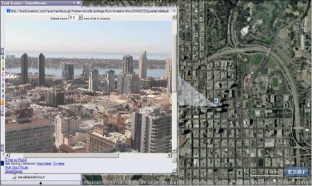
We have all used Google Maps and Google Earth with amazement. Google has done an incredible job of creating engaging and easy-to-use geography visualization tools. Streetview, a feature of Google Maps and Google Earth,  provides a 360° horizontal and 290° vertical panoramic views from a row of positions along streets throughout the world. The Streetview images were collected by a camera mounted on a car or truck; therefore, the images are limited to streets. Below VS (See Docs: 315612) shows us how to use Streetview from within our PortGIS Explorer Web Application.

Data collection is the hardest part of any GIS. Google has collected an incredible amount of ground level information as geospatially referenced images. At the Port, this tool can be used to identify an unfamiliar area or be used as part of QAQC process, but the real functionality comes across when we combine Streetview images and our Port data, such as the TidelandsMapbook2007. For example, with this tool in their arsenal our Land Use Planning Department can explore areas before construction or demolition takes place. Without switching to another system, they could also research adjacent tenants, their frontage, and when their lease agreements expire.

We also wrote a blog post on how to use Streetview from within the Harbor Police Desktop Application based on ArcGIS Explorer. We want to thank ESRI, and the tool’s author, for making it available to the public through ESRI’s .Net ADF Code Gallery. See the links below to learn more about these topics

Streetview in PortGIS Harbor Police desktop Application
https://posdgis.wordpress.com/2008/12/02/the-streetviewer-custom-task/

More information about implementing this tool:
http://resources.esri.com/arcgisserver/adf/dotnet/index.cfm?fa=codeGalleryDetails&scriptID=15788

GoogleStreetViewWeddingProposal Zen

PortGIS Task #2: Measure Task and Progress Update

November 17, 2008

Below is the next video in a series demonstrating how to use tasks within the PortGIS Software. With the measure tool you can determine elevation, latitude, longitude, distance and areas.

Progress Update:
We have a fully functional basic PortGIS for everyone on our internal network. This is the software demonstrated in all the videos so far. Recently we have made significant progress on the PortGIS (Harbor Police) deployment and on the development of the PortGIS (Engineering) software. The Harbor Police customization is done, and the next steps are to make sure the hardware is in place to support it, then push it to the proper users. We hope to have that completed within the next few weeks. This progress has been made at the expense of updates to this blog, and I apologize for that. We hope to keep the blog updated at least once a week.

We have contracted with Halcrow to help us with the PortGIS (Engineering)/CAD workflow. So far, I have created a script which grabs a CAD file and converts it to a usable GIS file. This script archives the two file formats. It is currently configured to run daily at 2:45 AM. We have reached the point where we know how to traverse the GIS/CAD divide. Jerry Wallenborn and his team from Halcrow are working with the engineers to come up with specific layer standards. We will adjust the script to display the CAD properly in the PortGIS. This is an immense task. One of the team’s major goals is to create a consensus among Port engineers in order to support these standards. He has a very warm and easy going personality. If you don’t already know Jerry, I suggest you come down to the annex and introduce yourself.

In the near future we hope to work on the goals below. Stay tuned.
SAP integration (Remote Function Calls)
Environmental Services (storm drain database integration)
Purchasing new aerials
Browser based display for Basic, HPD, and Engineering versions
Integration with Cumulus Software
And much more.

AncientRomeMapsZen

PortGIS (Harbor Police) to be Released

October 30, 2008

We hope to release PortGIS to the Harbor Police desktops within the next month. This release will include many enhancements over the PortGIS (Beta version). This rollout is going to have many firsts for us, including a full departmental PortGIS software push, a custom task, .NET software release on the server, and authentication and authorization within the Port network. Below is a list of the added functionality to the PortGIS (Harbor Police) release. I hope to have a video showing some of these features shortly. For now I will include snapshots.

The Harbor Police has been very supportive of our efforts in the GIS department and have been eager to embrace technological advances. LJJ and MR (See docs #315612) are working to bring hardware upgrades, or new computers to support the 1GB minimum software requirements for the PortGIS. There are something like 60x1gb RAM sticks and 30 brand new computers involved. It is a lot of work, and much of the credit for the PortGIS actually running on computers at the Port belongs to them and their teams.

1) Added 2005 in-house half-foot Imagery

1) Added 2005 in-house half-foot Imagery

2) Blocking out imagery outside the San Diego Area

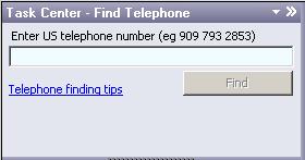
3) Added Find Telephone Task

3) Added Find Telephone Task(click image for more info)

4) Added Find Route Task

4) Added Find Route Task(click image for more info)

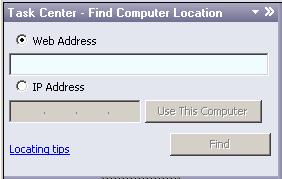
5) Added Find Computer Location Task

5) Added Find Computer Location Task(click image for more info)

6) Added Identify Task

6) Added Identify Task (click image for more info)

7) Added StreetViewer Custom Task

7) Added StreetViewer Custom Task (click image for more info)

8) 1)Ability to track vehicles, although still working out the kinks

8) Ability to track vehicles, although still working out the kinks

9) Access to public webcams in the San Diego area

9) Access to public webcams in the San Diego area

10) Customized help menu

10) Customized content and appearance of help

This release is still in development. Our hope is that the Harbor Police will start working with the product to hone in on exactly how they would like this tool to be used. Often when we solve a problem it creates new ones. For example; we can now track many of the vehicles, including those off-duty. So this raises the question: Even when they are on-duty; Is it necessary for the entire department to have access to their locations? Or, should we limit it to certain people, CSF (See docs #315612) and dispatchers. Just a little food for thought.

Amazing7yearOldBreakdancing Zen

PortGIS Task #1: Find Address

October 20, 2008

Below is the first video in a series demonstrating how to use tasks within the PortGIS Software. Our group of Beta Team members has grown to be around 20 people. Currently, Harbor Police, Environmental Services, Engineering and Construction, Information Technology, and the Real Estate departments each have a representative receiving updates and providing valuable input into the development of the PortGIS product. We would like to hear more comments and suggestions about how to tailor these tasks specifically for your needs. If you would like to add a fellow Port employee to the program please have them contact me.

How to install the PortGIS

October 7, 2008

Port Employees- Please do not follow these directions unless directed by IT staff.

We want this post to be the place where Port employees can learn about installing the Port GIS on their computers. Please send me an email if something is not clear or if you are having problems. When we officially deploy this software throughout the Port we will push it to you via an installer.

The directions to download, install and point to the PortGIS are written below. We have also included a video. The written directions assume that you have 1) at least 1gb of RAM and 2) the Microsoft .NET 2.0 Framework installed. If you have a fairly new computer both these requirements are probably met. If you need more RAM please contact MR.

Directions to install the PortGIS on your machine
1)    Download AGX from here (or by searching “ArcGIS Explorer”)
2)    Install AGX, accepting all the defaults


3)    Open AGX (start>All Programs>ArcGIS>ArcGIS Explorer)
4)    File>Set Home Server>Set Home Server Located At> Type in the path cooresponding to “BETA” (see Docs #315612).
5)    Click OK to restart AGX as PortGIS

How a few hours can turn into a week

October 6, 2008

The primary goal of this blog is to work with Port of San Diego employees to develop an easy to use GIS which will help them work more productively. Most GIS blogs are commentary on the GIS industry. I’d like to apologize to Port employees who wanted to start using the PortGIS, but haven’t gotten a chance. Changing operating systems/webserver platforms from WS2003/IIS5.2 to WS2008/IIS7 has created larger problems than we anticipated. Unfortunately, “a few hours” have turned into more than a week. However, I am happy to say that we are now up and running. If you are interested in the technical reasons please keep reading. If not, please check back in for future posts. The next post will include clear directions and a video to explain how to install the PortGIS.

We have had two major problems with the upgrade.

1) The AGX Home Server Files (AGXHSF) don’t work in IIS7 as they do in IIS6. I am not exactly sure of the reason, but it definitely has to do with the web.config file. ESRI’s lists “Internet Information Services (IIS) – required for the ArcGIS Explorer Home Setup” on ArcGIS Explorer Home Requirements section of their ArcGIS Explorer 500 System Requirements page. ESRI doesn’t refer to any version of IIS. ESRI support pointed out that ArcGIS Server is supported but the AGXHSF are not. ESRI is going to update their documentation to reflect this. Our workaround is to have the AGXHSF on WS2003 machine and our map services coming from the WS2008 machine. We would really like to have it all on one server.

2) We also have not figured out how to connect the WS2008 machine to our Novell domain. In addition to the project most discussed on this blog, we have non-ESRI GIS webapps using Apache Tomcat. These services work fine on the server machine, but cannot be deployed to users. Coworkers much more adept at dealing with this type of issue are working on this.

I will give ESRI the benefit of the doubt for 3 reasons. First because the AGS map services scream (79546 Kbps), second other software vendors have had similar issues, and third because this is a new product. The WS2008/IIS7 platform is the way of the future. I believe in the AGX + AGS combination to bring customized GIS capabilities into the regular workflow of organizations, such as the Port of San Diego. I don’t see any reason why they can’t run on the same machine. I hope ESRI can solve, or publish a workaround, for this issue with the next build of AGX.

Obstacles to Engineering and GIS

September 27, 2008

Malcolm and I presented today to the Engineering department showing the beta version of the PortGIS. Integrating Engineering could easily become our most difficult challenge. The major obstacle for us is this: Engineers produce/edit geometry (AKA geographic data, linework), while other departments are focused upon producing/editing table data associated with geometry. For example, Environmental Services would like to manage their Storm Water Inspection database through GIS. Their data will be associated with a point line or polygon (geometry), but they will not be producing/editing the geometry on a regular basis.

I’d like to propose my usual “begin with the end in mind”: I keep thinking about the example of a water utilities network and a task which would ask a question like “If a particular valve is turned off, which buildings won’t get water?” Engineers would be providing us with this data, meaning they would not only need to follow CAD standards but also GIS standards. As you can see, this could quickly become more trouble than it is worth. We have hired Halcrow as a consultant to help develop a sustainable, user friendly approach to this issue. We had a meeting with JW and BW (see Docs #315612) to kickoff phase 2 of this project. They seemed open to the idea of working with ESRI products, but we are depending on them to create a sustainable integration of Engineering drawings in the PortGIS.

I planned on including directions to install the software I showed at the Engineering meeting at the end of this post. The directions ended up being detailed and long winded. Instead, I have decided to include a video, and I promise to get together clear and easy directions to follow for early next week. The PortGIS is currently down due to a server operating system upgrade. Hopefully we can get it going again first thing Monday morning.

MissleOnGE zen

Display Options and Using Tasks

September 17, 2008

I had a little impromptu meeting with LJJ, of Harbor Police, and TW of Dispatch yesterday. LJJ mentioned that any GIS developed by the Port is going to be measured against Google Earth (GE). I think we can all agree that typing in an address and looking for directions is much more pleasant in GE than in most professional GIS systems out there. Searching for directions from one address to another in the ArcGIS desktop suite is cumbersome. ESRI knows this and has created ArcGIS Explorer (AGX). AGX looks and functions much like GE, but it allows us to point to our own internal server and use both ESRI proprietary data formats and non-proprietary formats. In many ways AGX exceeds the capabilities of GE. I created a basic video showing the display options and how to use Tasks in our Port GIS.

One last point, based on the number of acronyms I used in the last paragraph I am going to start keeping a list of their relevance in DM (Docs #315612). Please leave comments if you have problems accessing this list.

Some freestyle horse zen

How to create a PDF, image and print

September 16, 2008

To get CutePDF you will need to download and install 2 separate programs Ghostscript and CutePDF (click links 2 download). Sorry about the video quality-i’m working on it.

click for some not LJJ zen